Showing posts with label flood. Show all posts
Sep 6, 2024

Revisiting the Marikina mega dike project along Marikina River

The Marikina mega dike project along Marikina River has been ongoing for several years, with various phases and updates throughout its construction.  
Here's a summary of the latest information:


Progress:
Phase 3: As of 2020, Phase 3 of the project was completed, which included dredging the Manggahan floodway to increase its flood capacity.

Ongoing work: The project is still ongoing, with construction continuing on different sections of the dike.

Revised design: The original design of the road dike project has been revised and is now called the Riverside Development, which involves raising the elevation of some areas and constructing drainage outfalls.

The Marikina mega dike project is progressing, with various phases completed and ongoing work. The project aims to mitigate flooding in the Marikina area

In the meantime, the Pasig-Marikina River Channel Improvement Project - Phase IV, which includes building the Marikina Control Gate Structure, and the Metro Manila Flood Management Project, involve building and enhancing pumping stations along vital waterways.

Senior Undersecretary Sadain stated that in order to ensure safe flow of the remaining floodwaters through Metro Manila without causing significant flooding, two additional proposed projects are an Upper Marikina Dam, located approximately four (4) kilometers upstream from the current Wawa Dam in Montalban Gorge, and a retarding basin, located downstream of the Marikina River Basin. These projects are intended to help reduce peak river flows entering Metro Manila during typhoons and extreme rainfall.

Jul 23, 2024

Where To Find Important Marikina City Weather and Flood Updates

Now that the rainy season has begun, expect weather disturbances in Metro Manila including Marikina City for the next few months. Be updated with weather and water level status in Marikina by following and checking with these useful online sources:


Marikina City Rescue 161

https://www.facebook.com/MarikinaRescue161

This is the official Facebook page of Marikina City Rescue 161 located at Marikina City Disaster Risk Reduction Management Office building, Fortune avenue, Marikina City.
Aside from posting periodic and critical weather updates from www.pagasa.dost.gov.ph, they also provide Marikina Rainfall Reading status updates.

Also during heavy rains or when water levels at Marikina River rise above the average level, a livestream showing the Marikina River water level. This is handy especially for residents and families who live near the Marikina River areas, or are directly affected by rising water levels.

Sample video streamed live by Marikina City Rescue 161

Save these handy numbers in case of emergencies:

MARIKINA RESCUE 161 HOTLINE
8- 646 2436 to 38
8- 646 0427
7- 273 6563

Mobile Number
0917 - 584 - 2168 ( GLOBE )
0917 - 804 - 6352 ( GLOBE )
0928 - 559 - 3341 ( SMART )
0998 - 997 - 0115 ( SMART )
0998 - 579 - 6435 ( SMART )

Email : drrmo.marikinacity@gmail.com
Facebook Messenger : Reskyu Onesixone
Facebook Account : Marikina City Rescue

Marikina PIO on Facebook

https://www.facebook.com/MarikinaPIO

This is the official Facebook page for the Marikina Public Information Office. They serve as an outlet for the Marikina City government to disseminate information. Aside from posting public service announcements and updates from different government sectors related to Marikina City, they share useful updates from different sources, like Marikina River livestreams from Marikina City Rescue 161 during above-average rainfall affecting the city.

Sample status update includes rainfall count and Marikina River water level

Flood Information (PAGASA Website)

https://bagong.pagasa.dost.gov.ph/flood

This page lists 18 major Philippine river basins, including NCR/Pasig, Marikina, and Laguna de Bay. Click on the "Flood Watch" status link to see the latest flood bulletin report. The report includes details like the current weather condition, average rainfall in the basin, a 12-hour forecast, the most likely affected water courses, and a list of awareness, information, and advice for reference. These details are useful to gauge how the flood situation will be in the next 12 hours and what action to take, such as being alert for flash floods. 


Share this post with friends and family who live in Marikina City for awareness and empower affected people with timely updates for residents.


Sep 26, 2022

Reflections This 13th Anniversary of Typhoon Ondoy

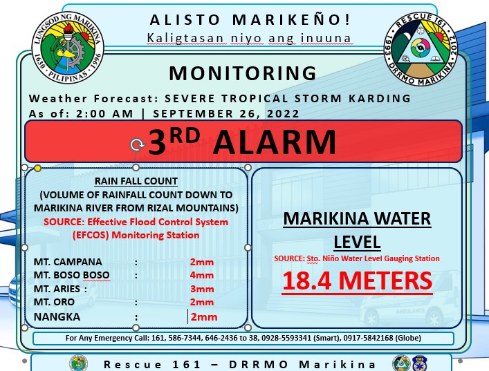
As Typhoon Karding made landfall in the Philippines on September 25, 2022, it brought strong winds and torrential rain to the country, including Marikina City and nearby areas. Typhoon signal #3 was also raised in Marikina City.

Just past midnight, Marikina River's water level rose above 18 meters raising the alert level to 3rd alarm.
It reached its peak around 2:00am at 18.4 meters and slowly decreased in the next 9 hours to 15.9 meters, lowering the alert level to 1st alarm.

The typhoon somehow reminded me of Typhoon Ondoy, when waters drastically rose in the evening and all through the night. 

Coincidentally, September 26, 2022, marks the 13th anniversary of when Typhoon Ondoy hit the Philippines. During Tropical Storm Ondoy in 2009, Marikina River's water level reached an all-time high of 21.5 meters.

Even if I now live in a safe area, I still worry when there are non-stop rains and typhoons because my parent's home in SSS Village has experienced floods in the past. I know very well the feeling of anxiety while non-stop rains pour down, the sense of checking the street for floods every few minutes, the adrenalin of lifting furniture and other moving belongings to a higher place while flood water enters your house, the sense of despair when electricity goes out when you most need it, and safe guarding your house the whole night even if you're very tired and sleepy. Experiencing all this is something you'll perfect in time but hoping you won't need to experience it.
Katipunan St, SSS Village in 2009 during Typhoon Ondoy. Since the construction of major drainage systems improvements, Katipunan rarely floods now.


The good thing is that there were many lessons learned from Ondoy, not just from each Marikeño but also by local government. Thanks to the many protocols set into play plus the use of technology to assist us, it has been easier to cope with typhoon and floods.

Thanks to these online resources and public services that can greatly assist us with information and assistance we need to better prepare for not just any typhoon but also any calamity that comes our way:
map of Marikina's flood-prone areas by Nationwide Operational Assessment of Hazards (NOAH) 


Other initiatives like declogging of waterways, canals, and sewers before a typhoon hits greatly help the quick and steady flow of rainwater. 

Indeed, Marikina City has come a long way in ensuring the safety and well-being of its residents. It's reassuring that something as devastating as Typhoon Ondoy in 2009 can be prevented and not have a maximum impact as typhoons used to in the city.

Marikina River Reached Alert Level 3 On Ondoy's 13th Anniversary (September 26, 2022)

As Typhoon Karding made landfall in the Philippines on September 25, 2022, it brought strong winds and torrential rain to the country, including Marikina City and nearby areas. Typhoon signal #3 was raised in Marikina City along with the northern portion of Metro Manila (Pasig, Quezon City, San Juan, Mandaluyong, Manila, Navotas, Malabon, Caloocan, Valenzuela.)


Just around midnight on September 26, Marikina River's water level reached 18 meters raising the alert level to the 3rd alarm. 

From September 26, 4:00am onwards, Marikina River's water level slowly decreased.
  • 18.4 meters - 2:00am (3rd alarm)
  • 18.2 meters - 4:00am (3rd alarm)
  • 17.6 meters - 6:00am (2nd alarm)
  • 17.0 meters - 7:30am (2nd alarm)
  • 16.9 meters - 8:00am (2nd alarm)
  • 16.7 meters - 8:32am (2nd alarm)
  • 16.3 meters - 9:30am (2nd alarm)
  • 15.9 meters - 10.44am (1st alarm)
  • 15.7 meters - 11:14am  (1st alarm)

Coincidentally, September 26, 2022, marks the 13th anniversary of when Typhoon Ondoy hit the Philippines. During Tropical Storm Ondoy in 2009, Marikina River's water level reached an all-time high of 21.5 meters.

Related posts:

Sep 25, 2022

NOAH Helps You Find Areas Affected by Floods, Storm Surges in Marikina

During typhoon season, Marikina City is known to be affected by flooding due to torrential rains from both within Marikina and higher nearby areas. 

If you live in Marikina, you'll probably know which streets and barangays experience flooding. If you're unfamiliar, there is an online tool showing areas where flooding is experienced.

Thanks to the Nationwide Operational Assessment of Hazards (NOAH), they offer an online service that shows areas that are affected not only by floods but also landslides and storm surges. The website shows a map based on your location or a location you enter and will retrieve a visual representation of areas affected. The map can be zoomed in to street level or zoomed out to barangay and city level. The map is based on archived data and not a real-time source for monitoring floods. It does become a handy reference for motorists to determine what areas are prone to flooding without having to experience a real flood.


Visit https://noah.up.edu.ph to access the tool and you will be asked to input your location or any other location. You can type in an address from the street level and it will retrieve results of possible locations.


Project NOAH is still in beta release. There are ongoing developments to stabilize the platform and to complete the hazard maps


Aug 15, 2016

Floating Crane Spotted Drifting in Marikina River

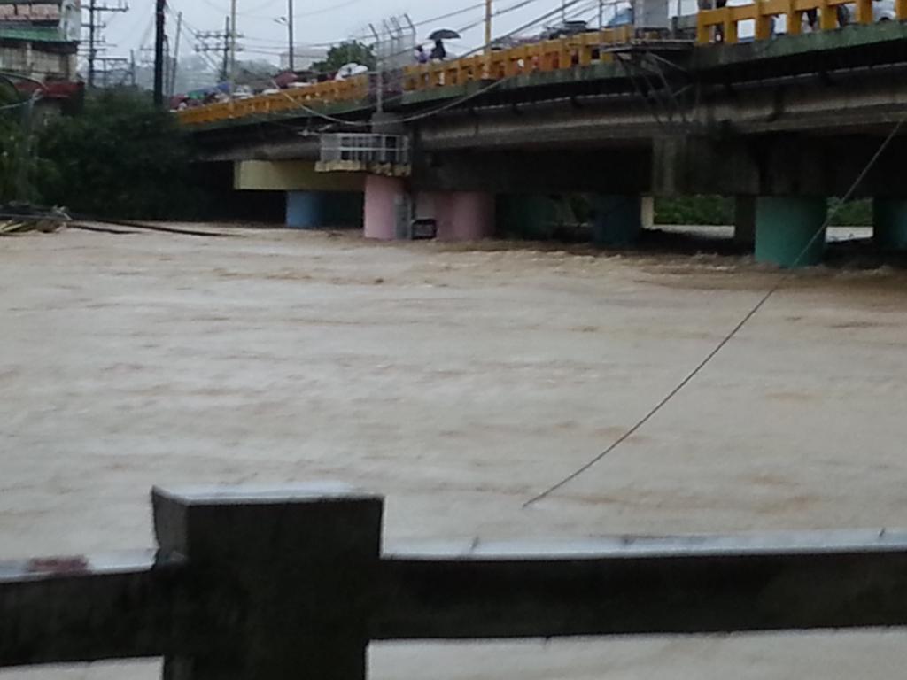
Last August 13, 2016, around 2:30pm, a crane on a barge was dislodged from the Marikina River banks and floated along the Marikina River. A portion bumped into the pillars beneath the Marikina Bridge as it floated underneath the bridge.  On the floating device was 19 year old Romeo Laguna, who was able to jump away from the barge and was rescued by Marikina City personnel before the crane eventually sunk when it collided with the Marcos Bridge, Marcos Highway.

(amateur footage of barge with crane passing through Marikina Bridge dislodged by Marikina high water levels)
(barge with crane passing underneath Marcos Bridge flips and sinks)
According to Marikina Mayor Marcy Teodoro, the crane was situated by the side of Marikina River which was currently used for dredging and piledriving by the riverside for slope protection. Unfortunately, the water level rose at quick rate, unlocking the floating device and crane from its position.

Due to continuous rains brought by Habagat, the water level reached 18.6 meters around 6pm. Eight floodgates were opened to lower the water level. By 9:45pm, water level receded to 17.5 meters.

According to Panahon.tv, as of August 15, 9:00am, water level has receded to 14.8 meters and all flood alerts have been lifted. However, classes in all levels have been suspended for Marikina.

 Here are some news report situationer updates on Marikina River and the weather.
Addendum: This is the not the first time large man-made objects floated and crashed into the bridges in Marikina. In 2012, a floating stage also crashed into the bridge causing it to be schredded into pieces.
Sep 19, 2014

Online Resources for Marikenos on Typhoon Mario

With Typhoon Mario's amount of rainfall hugely affecting Marikina City, Mayor Del De Guzman declares the city in a state of calamity. Residents in surrounding areas of Marikina River were issued a force evacuation as standard protocol once Marikina River reaches critical level.  As of 5pm today, Adrian Ayalin reports current river level at 19.8 meters, which is above the 17 meter critical level.
Marikina river at 19.8 meters as of 5PM. pic.twitter.com/hXR8d9mdMn  — Adrian Ayalin (@adrianayalin) September 19, 2014


The sudden flash floods experienced prompted some Marikenos to compare Typhoon Mario with 2009 Typhoon Ondoy.  PAGASA recorded 268 mm of rainfall in the past 12 hours as compared to Typhoon Ondoy's 455 mm in a 24 hour time frame and notes that their forecast shows that Typhoon Mario will not likely achieve the same amount.

To assist Marikenos, here are some online resources available:

 Evacuation centers where families have been relocated due to TS Mario.
(Resource: DSWD/PCDSPO)

Other city announcements:

  • Mayor Del announces the suspension of classes in all levels for Saturday, Sept. 20, 2014 in Marikina.
Aug 19, 2013

Flood Alert Level Guide & Online Resources for Monitoring Marikina River & Floods

Marikina City has a four-stage alarm level system for the Marikina River:
  • Alarm Level 1, when the water is 15 meters above sea level, means "warning" (babala)
  • Alarm Level 2, when the water is 16 meters above sea level, means "prepare" (maghanda)
  • Alarm Level 3, when the water is 17 meters above sea level, means "evacuate" (lumikas)
Stock Photo - Marikina River
These alarm levels are based on the depth of water in Marikina River (Sto. Nino). Malanday, Nangka and Tumana are considered critical areas.


Also follow these Twitter accounts for Marikina updates.

Marikina Public Information Office
PIO Marikina ‏@MarikinaPIO
https://twitter.com/MarikinaPIO

Official Twitter Account of Philippine Atmospheric, Geophysical and Astronomical Services Administration (PAGASA-DOST)
PAGASA-DOST @dost_pagasa
https://twitter.com/dost_pagasa

Marikina Local Government Unit
Marikina LGU ‏@MarikinaLGU
https://twitter.com/MarikinaLGU

Rescue PH
RescuePH ‏ @RescuePH
https://twitter.com/RescuePH
We coordinate with rescue units in the Philippines. Please use the hashtag

For regular updates on the Marikina water level, access 
for important information about Marikina River Water Level including rainfall in Antipolo, Montalban and other watersheds and Typhoon updates.
UPDATE: As of July 2015, the link above does not work anymore.
Project NOAH (Nationwide Operational Assessment of Hazards)
http://noah.dost.gov.ph/
Project NOAH is the Department of Science and Technology’s (DOST) response to the call of President Benigno S. Aquino III for a more accurate, integrated, and responsive disaster prevention and mitigation system, especially in high-risk areas throughout the Philippines.

Project NOAH is also available as a mobile application on the Android platform.
Aug 7, 2012

Marikina River Water Level Updates

For live updates on Marikina River water level, visit http://marikina.gov.ph/#waterlevel

It displays water levels for Sto Nino, Nangka, Montalban, Angono and Rosario
The page auto refreshes every 2 minutes for new updates.
Sample data from  http://syncsysph.com/councilmarikinagovph/data/riverlevel.html 

 As a guide, alarm levels are as follows:
  • ALARM LEVEL NO. 1 – 15 METERS reference at sea level – WARNING 
  • ALARM LEVEL NO. 2 – 16 METERS reference at sea level – PREPARE 
  • ALARM LEVEL NO. 3 – 17 METERS reference at sea level – EVACUATE
For updates on rainfall for the areas of Antipolo, Bosoboso, Nangka and Montalban, visit http://syncsysph.com/councilmarikinagovph/data/rainfall.html
Sample data from  http://syncsysph.com/councilmarikinagovph/data/rainfall.html 
Nov 25, 2009

Excess Mud

Typhoon Ondoy has not only brought floods to Marikina but a tremendous amount of mud as well. Mud was everywhere and anywhere floods were during the typhoon. When the floods subsided, the massive amount of mud was left.

The mud was cleaned and collected and eventually placed in designated areas. Weeks after the extensive city cleaning, the mud eventually hardened and turned into dirt and soil.

Now, the city has an excess of soil. One of the biggest designated areas where the soil was dumped was underneath the Marcos Highway bridge right beside the Diosdado Macapagal Bridge near SM City Marikina. The soil was compacted and neatly stacked in a way that it doesn't look like a sight for sore eyes. In fact, it looks a bit like Egyptian ruins.

The service roads from SM City Marikina leading to Marcos Highway are still closed to traffic as part of the roads are used to maintain the excess soil.
Nov 20, 2009

Bangon Marikina

Bangon Marikina is a phrase which you'll find in various parts of Marikina City, denoting to the mishap the city has undergone during the Typhoon Ondoy floods.

The phrase also serves as motivation and optimism that the great city of Marikina will rise again after the devastation the city has undergone.

Oct 19, 2009

LG Service Camp for Typhoon Victims

Due to the recent floods in Marikina, LG has put up a Service Camp to cater to city residents who may have any LG appliances that were submerged in flood waters. The LG Service Camp is located at the parking lot in front of the Main Post Office and will accept any LG appliances that require repair from October 19 to 31, 2009 from 9am - 6pm. For more inquiries, contact the LG customer service at 902-5542.
Oct 5, 2009

Raging Marikina River During Typhoon Ondoy

At the height of Typhoon Ondoy, Marikina River had doubled in size and the immense water from the rains and dam had the river overflow to all the nearby areas.

This is one of the most disturbing and saddening videos captured during the storm. These people were literally in the middle of the river and staying alive only by standing on debris being swept by the river. The fast current was only a few feet before reaching the bridge. Unfortunately, not all of the people survived as the waters slammed into the lower part of the bridge.
Oct 3, 2009

Marikina Sports Center Temporarily Closed

The Marikina Sports Center is one of the most visited multipurpose centers in Marikina. As early as five in the morning, people of all ages come to jog around the olympic sized track and field. The field is also used for non-sports activities like concerts, religious meetings, anniversary celebrations and other various events as the bleachers alone can hold thousands of people.
Unfortunately, the Marikina Sports Center wasn't spared from the floods brought about by Typhoon Ondoy. Because of this, the center grounds have been filled with mud inches thick and need to be cleaned before the Sports Center can resume operations.
The new Sports Center Building of the Sports Complex facing the Marikina City Hall is currently being used as storage and delivery for relief goods for the city.

Sumulong Highway Serves As Temporary Garbage Site

Marikina City has suffered much from the floods brought by Typhoon Ondoy.

The floods have subsided in most of the affected areas. However, sanitation has proven to be one of the problems the typhoon has left.

Mud is prominent everywhere and garbage is at an all-time high. Due to the enormous amount of trash, the fields alongside Sumulong Highway has served as a temporary dumpsite until the garbage trucks can pick them up.

The heaps of garbage though causes a foul stench within the surrounding areas. Scavengers are also searching the garbage mounds for anything of worth they can salvage.


Oct 1, 2009

Bluewave Marquinton and Robinsons Flooded During Typhoon

Both Bluewave Marquinton and Bluewave Robinsons along Sumulong Highway were both submerged in water during the sudden floods brought about by Typhoon Ondoy. This is the first time that the mall and supermarket have been directly affected by floods.

Several stores located on the ground floor of both buildings were severely affected.
Bluewave Marquinton ground floor stores and restaurants include Max's Chicken, KFC, Yellow Cab, Starbucks, Shakeys, Jollibee, Ministop, Tapa King, Pan de Manila and Watsons.

Aside from the supermarket at Robinsons Bluewave, it also caters to Mercury Drug, Joey Pepperoni, Rai-Rai Ken, Binalot and Mr. Quickie.

The supermarket would have been a crucial place for Marikina residents to buy food and items needed after the typhoon. Unfortunately, the supermarket fell victim to the floods as well.

We're hoping that the Bluewave Marquinton mall resumes operations as soon as possible.
Sep 29, 2009

Google Responds To Typhoon Ondoy Calamity

Here is a message from Google:

We are very saddened by the loss of life and the displacement of hundreds of thousands of people in Metro Manila and nearby areas caused by Typhoon Ondoy. To increase awareness of how Filipinos at home and overseas can stay up to date and aid in relief efforts, dozens of Google volunteers around the world have been working throughout the weekend and today to compile information about the disaster on this site: www.google.com.ph/landing/typhoon-ondoy.html.


The site contains a volunteer-maintained map of flood updates and persons needing rescue, the latest news from local media sources, a list of verified donation sites and emergency hotlines. It is also linked from Google.com.ph to give easy access to the 25 million Internet users in the Philippines and many more around the world.

Our effort is but one of many being organized by countless individuals and organizations across the country in the spirit of bayanihan, to help those affected by this disaster as quickly and as comprehensively as possible.

Thanks

View Ondoy situation map for Metro Manila in a larger map
Jul 18, 2009

Marikina River Rises due to Continued Rains

Typhoon "Isang" has caused heavy rains all over the Metro. Even though Metro Manila isn't directly affected by the storm as there is no storm signal over the National Capitol Region, the non-stop rains over the last few days has caused the Marikina river to rise beyond normal levels.

Philippine Atmospheric Geophysical and Astronomical Services Administration (PAGASA) announced that "Isang" was moving toward Hong Kong and southern China, with winds whipping at 95 kilometers per hour.

Residents near the river banks of San Mateo and Marikina have been heavily affected as waters have risen from knee-deep to chest-high. Affected families have been evacuated to the Nangka public school.

The Marikina RiverPark has doubled in width and the walkways on both sides of the river have been submerged. Floods and high waters are expected to subside as long as the rainfall decreases.
Jul 2, 2009

Katipunan Road - Victim of Flash Floods

Marikina City is a valley with with the elevated Antipolo, San Mateo and Quezon City all lying around its boundaries. Even with the presence of the Marikina River, it's not enough to handle the additional downpour of water from nearby areas when it rains and even if it doesn't heavily rain in Marikina City, some places could be subject to flooding due to rushing waters from the mountains.

One of the commonly flooded areas is the stretch of Katipunan Road in Concepcion Dos. This main artery serving as a shortcut from Sumulong Highway to Marikina Heights is subject to flash floods during the rainy season. The waters usually are knee-high during initial flash floods but could go up to waist level at its deepest during extreme weather conditions.


Katipunan Road has been a problem flooding area for decades. Two hospitals, namely, SDS Medical Center and Immaculate Concepcion Hospital, are right at the center of the flood which stretches from the corner of Tangerine St. to Rainbow St. The floods extend to Aquamarine St. and Russet St. rendering them virtually impassable to light vechicles.

The major improvement through the past years is that the flash flood easily disappears in 1-2 hours as soon as the rains stop. Being a main road though, it causes a major standstill as motorists park their cars at the Katipunan-Sumulong road while waiting for the waters to subside. Let's hope Marikina doesn't experience much flooding this rainy season.
Jun 1, 2009

Sumulong Highway to Undergo Drainage and Road Improvement

For the past few days, heavy rainfall has poured due to a low pressure area.   Unfortunately, some roads in San Roque intersecting Gil Fernando Ave and some backroads in San Roque, have experienced partial flooding, inlcluding Redwood (near Metrobank), Dasdasan (near Biksa Coffee) and Bangkilya roads within the residential areas.

Sumulong Highway is also experiencing some flash flooding in front of the Marikina Valley Medical Center and in front of the area where Toledo Towers is soon to rise.  The flooding area incidentally is the same area which has just been asphalted a few months ago.

Fortunately, I've seen signs along that area with a picture of Congressman Marcy, stating that he will be spearheading a project to improve drainage and road condition of Sumulong Highway.   Let's hope that this can be done before the rainy season begins to avoid flash flooding along Sumulong Highway.