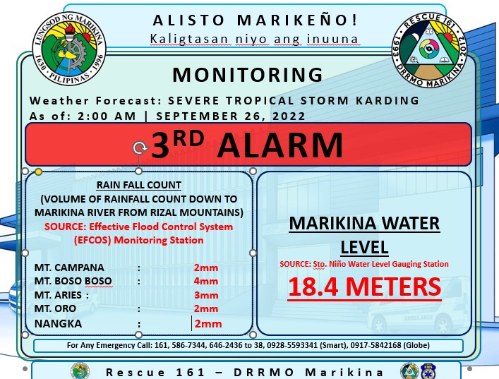
Just past midnight, Marikina River's water level rose above 18 meters raising the alert level to 3rd alarm.
Revisit Typhoon Ondoy's effect on Marikina City
It reached its peak around 2:00am at 18.4 meters and slowly decreased in the next 9 hours to 15.9 meters, lowering the alert level to 1st alarm.
The typhoon somehow reminded me of Typhoon Ondoy, when waters drastically rose in the evening and all through the night.
Coincidentally, September 26, 2022, marks the 13th anniversary of when Typhoon Ondoy hit the Philippines. During Tropical Storm Ondoy in 2009, Marikina River's water level reached an all-time high of 21.5 meters.
Even if I now live in a safe area, I still worry when there are non-stop rains and typhoons because my parent's home in SSS Village has experienced floods in the past. I know very well the feeling of anxiety while non-stop rains pour down, the sense of checking the street for floods every few minutes, the adrenalin of lifting furniture and other moving belongings to a higher place while flood water enters your house, the sense of despair when electricity goes out when you most need it, and safe guarding your house the whole night even if you're very tired and sleepy. Experiencing all this is something you'll perfect in time but hoping you won't need to experience it.
 |
| Katipunan St, SSS Village in 2009 during Typhoon Ondoy. Since the construction of major drainage systems improvements, Katipunan rarely floods now. |
The good thing is that there were many lessons learned from Ondoy, not just from each Marikeño but also by local government. Thanks to the many protocols set into play plus the use of technology to assist us, it has been easier to cope with typhoon and floods.
Thanks to these online resources and public services that can greatly assist us with information and assistance we need to better prepare for not just any typhoon but also any calamity that comes our way:
- Zoom Earth - provides update on typhoon movements and forecasts
- Nationwide Operational Assessment of Hazards (NOAH) - mapping tool that shows areas that are possibly affected by floods, landslides, and storm surges
- Marikina City Rescue 161 Facebook page - providing live stream and real-time status of the Marikina River water levels
- Marikina PIO (Public Information Office) - shares city updates including flood alert levels, typhoon info, and city initiatives
- Inside Marikina - huge Facebook community sharing public service advisories and current events
- Nearby malls such as Ayala Malls Feliz, Ayala Malls Marikina, SM City Marikina, SM City Masinag (Official), and Robinsons Metro East who provide free overnight parking for motorists affected by typhoon and floods and wish to seek temporary shelter.
 |
| map of Marikina's flood-prone areas by Nationwide Operational Assessment of Hazards (NOAH) |
Other initiatives like declogging of waterways, canals, and sewers before a typhoon hits greatly help the quick and steady flow of rainwater.
Indeed, Marikina City has come a long way in ensuring the safety and well-being of its residents. It's reassuring that something as devastating as Typhoon Ondoy in 2009 can be prevented and not have a maximum impact as typhoons used to in the city.
Revisit Typhoon Ondoy's effect on Marikina City
- Remembering Typhoon Ondoy 7 Years Ago (Sep 27, 2016)
- Google Responds To Typhoon Ondoy Calamity (Sep 29, 2009)
- Bluewave Marquinton and Robinsons Flooded During Typhoon
- Sumulong Highway Serves As Temporary Garbage Site (Oct 3, 2009)
- Marikina Sports Center Temporarily Closed (Oct 3, 2009)
- Raging Marikina River During Typhoon Ondoy (Oct 5, 2009)
- Garbage Disposal Problem Brought About By Typhoon (Oct 6, 2009)
- Excess Mud (Nov 25, 2009)